What you should know about the History of Ngorongoro Crater
There can be few people who have not heard, read, or seen the film or TV footage of this incredible 20-km-wide volcanic crater with its 600-meter walls packed with just about every species of wildlife to be found in East Africa. The views from the crater rim are incredible, and though the wildlife might not look too impressive from up there, when you get to the bottom you will very quickly change your mind.
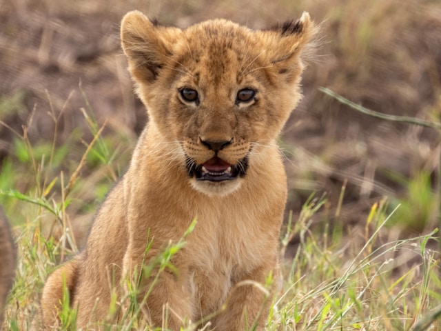
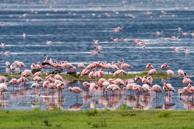
It’s been compared to Noah’s Ark and the Garden of Eden and it does not come up to Noah’ Ark expectations these days, but you definitely see lions, elephants, rhinos, buffaloes, and many of the plains herbivores such as wildebeest, Thomson’s gazelle, zebras, and reedbuck, as well as thousands of flamingos wading in the shallows of Lake Magadi- the soda lake on the floor of the crater.
Despite the steep wall of the crater, there’s considerable movement of animals in and out – mostly to Serengeti, since the land between the crater and Lake Manyara is intensively framed. Yet it remains a favored spot for the wildlife because there are permanent water and pasture on the crater floor. You can visit Ngorongoro at any time of the year and Jolita Safari will be delighted to prepare a trip for you.
Ngorongoro Crater History
Ngorongoro and the nearby craters and volcanoes are fairly recent additions to the landscape, geologically speaking. Though there has been a considerable amount of volcanic activity in the area for about 15 million years, Ngorongoro is thought to date back only 2 and 1/2 million years and may at one time have rivaled Mt Kilimanjaro in size. Its vents filled with solid rock, however, and the molten material was forced elsewhere.
As the lava subsided, circular fractures developed, and the cone collapsed inwards to form the caldera. Nevertheless, minor volcanic activity, continued as lava found cracks on the caldera floor and on the flanks of the mountain, creating the small cones and hillocks which you can see on the floor of the crater. Only in the 1930s was a road constructed through Ngorongoro and the lodge built on the rim, but even before WW 2 the crater had acquired International fame as a wildlife area.
In 1951 it was included in the newly created Serengeti National Park. It was hived off five years later due to the conflict between the park authority and the local Maasai, who felt that being excluded from the Serengeti was bad enough but that to have their grain rights to Ngorongoro also withdrawn was going too far. As a result, it became a conservation area for the benefit of pastoralists and wildlife alike. In recognition of its importance and beauty, it was declared a World Heritage site in 1978.
Indeed, Ngorongoro is an incredible and awe-inspiring place for the best extraordinary wildlife view. Feel free to share your thought and experience from the Ngorongoro conservation area, and in case you have any questions or need more info about this amazing place in northern Tanzania, then do not hesitate to contact us and we will be happy to assist you.
Ngorongoro Crater Details and Information Before You Go
Around 2.5 million years ago, a massive explosion caused the magma reservoir beneath a massive volcano that towered above the western edge of the Great Rift Valley to completely empty itself, leaving a vacuum that forced the mountain to collapse under its own weight. It left behind a massive 600-meter-deep crater (caldera), which is presently the biggest unbroken and unflooded caldera on the whole planet due to its 19-kilometer circumference.
This is the Ngorongoro Crater, one of Tanzania’s natural wonders that are around 300 square kilometers in size and serves as a natural amphitheater for the animal extravaganza that takes place on its floor. The crater is home to between 25,000 and 30,000 huge creatures, which are visible from the rim as a blur of pulsing dots grouped in fluid shapes. Eagles, buzzards, hawks, and vultures are circling above the crater.
The shallow, alkaline Lake Magadi, whose size changes according to rainfall and where flocks of flamingos forage during the dry season, is the major feature of the crater floor. The Datooga (Tatoga), the progenitors of the Barbaig cattle herders who occupied the crater until the Maasai drove them out, are said to have left an unexplained scattering of stone burial mounds on the western side.
Lerai Forest, a sizable area of acacia woodland on the southern shore of the lake, gets its Maasai name from the dominating yellow-barked acacia. It is a fantastic spot to watch waterbuck and fluttering sunbirds. The majority of the game watching is located in the crater’s remaining swamp, thorn scrub, and grassland.
There are large herds of wildebeest (up to 14,000), zebra, buffalo, Grant’s and Thomson’s gazelle, eland, hartebeest and mountain reedbuck, warthog and hippo, as well as two of Africa’s giants: elephants, of which a few bulls are always present, and a small population of black rhinos. Herbivores make up the majority of the animals. Rhinos were formerly prevalent over much of eastern and southern Africa. The Ngorongoro rhino received a serious blow in 2000–2001 even though poaching is now under control.
The main attraction, aside from rhinos, is the spellbinding sight of Africa’s most numerous predators in action. Hyenas, jackals, and lions are all often encountered and simple to spot (dry season is optimum). As they rest up in trees or dense vegetation during the day, cheetahs and leopards, which may be spotted with some patience, are occasionally present as well as with the best professional guides.
Three access roads are available. You may go in either way along the eastern Lemala road from the campgrounds at Lemala and Tembo. The Seneto path in the west is exclusively for the descent, but the Lerai route in the south is steeper and starts from the crater floor. In addition to entry fees, there is a fee of $300 per vehicle for six hours (in practice, a morning or afternoon game drive), and if you’re driving yourself, you’ll need to hire a licensed guide (this does not apply if your driver is licensed by the authorities, or if you’re on an organized safari).
The crater is only accessible by 4WD vehicles, which also need to have a heavy-duty jack, chains, or a towrope. Start rising no later than 5.30 pm since the speed restriction is 25 kph and you must leave by 6 pm. Except for two picnic areas—one at Ngoitokitok Springs in the east, adjacent to a tiny lake, and the other next to Lerai Forest at the foot of the Lerai climb route—visitors must remain in their vehicles.
Olmoti and Empakaai craters
Olmoti and Empakaai, two smaller craters, are located to the north of Ngorongoro Crater. Although either rim may be accessed by car, it is preferable to view them on foot as part of a planned excursion across the Crater Highlands. Even though both craters are near ranger stations, it is recommended to plan and arrange for a ranger to accompany you if you desire to walk. You can contact Jolita Safari for detailed information.
There are various antelope species in the shallow, grassy Olmoti Crater, which can be reached from Nanokanoka settlement, and nearby Munge River waterfalls. The crater rim and its surrounding forest may be explored on foot for two to seven hours while being accompanied by an armed ranger.
The breathtakingly gorgeous, 6 km wide Empakaai Crater, which is northeast of here, is largely filled with a soda lake bordered by forests. More wildlife may be seen here than at Olmoti, and among of the resident species are buffalo, monkeys, flamingos, reedbuck, waterbuck, bushbuck, and buffalo.
Ngorongoro Crater Highlands
The hilly eastern portion of Ngorongoro, which the Maasai refer to as Ol Doinyo Lengai and constitutes the lush wooded slope of the Great Rift Valley’s western escarpment, is known informally as the “Crater Highlands.” In addition to the Ngorongoro Crater, the region is home to the 3216-meter Mount Oldeani, the remote Gol Mountains in the north, the Olmoti and Empakaai craters in the northeast, Mount Loolmalassin, the highest point in the range at 3648 meters, and Ol Doinyo Lengai, the only active volcano in East Africa, which rises in a perfect cone just outside the conservation area’s northeastern corner.
A Crater Highlands hike is one of the main draws of Ngorongoro; it may take anything from a half-day to a week, allowing you plenty of time to reach Lake Natron and perhaps include a climb up Ol Doinyo Lengai along the way. Depending on where you start and if you’re being driven a portion of the way, the actual distance and number of days necessary will vary. For instance, a seven-day vacation allows you to amble at your leisure from the rim of Ngorongoro Crater to the desolately gorgeous Lake Natron, overnighting at Maasai bomas or camping in the open. A two-day (44 km) hike to Lake Natron begins at Empakaai Crater. Five-day tours are the norm for most safari firms. Contact Jolita Safari right now for more details.
These excursions are sometimes conducted by Maasai warriors, who make up for their somewhat weak English proficiency with their extraordinary practical botany knowledge and an incredible eye for animals. Contact us right away for longer safaris to Crater Highlands excursions.